|
Learn about
the Big Bend Country of Texas by reading Big Sky Plus
Big Bend Equals Big Adventure by Charlie Spence, Travel
Writer and WTA Member. It features a mini, but thorough tour of
the destination, plus all you'll need to know to plan your trip
including getting there, objective information on places to stay
and eat, and things to do. At the end of the article, we've
provided a summary of the contact information for your easy
reference. Enjoy!
Big Sky Plus Big Bend Equals Big
Adventure – Flying to the Big Bend Country of Texas
by Charlie Spence,
Travel Writer and WTA Member
When you visit
the Big Bend Country of Texas, there are so many things to see and
do that one of your difficult decisions will be what to enjoy on
this trip and what to save for a future visit. Big Bend gets its
name from the big curve in the Rio Grande in Southwest Texas and
Northern Mexico. The area is part of the vast Chihuahuan Desert that
extends from Central Mexico into New Mexico and here you will find
three different life zones: river, desert and mountain.
There are millions of acres of public land in this vast, remote, and
wildly beautiful region, but also nestled in are unique small
communities and plush four-star resorts. The Big Bend National Forest
and the Big Bend Ranch State Park offer diverse activities for the
lovers of the rugged outdoors or the more laid back, “I just want to
relax and admire the solitude and scenery” persons. The Big Bend
National Park is the only park in the United States that contains a
complete mountain range—the Chisos. Hiking, horseback riding, mountain
bicycling, Jeep touring, and river running are just of a few of the
activities awaiting adventurers. Just meandering through the area in an
auto over the paved roads offers the less adventurous the opportunity to
ooh and ah at the magnificent scenery around almost every curve.
For
river runners, there are five major and several smaller canyons in the
more than 250 miles of protected river in Big Bend State Ranch Park, Big
Bend National Park, and Rio Grand Wild and Scenic River. Walls of
several of these canyon rise as much as 1500 feet offering some of the
most awesome wilderness scenery found anywhere. Some canyons can be
navigated in a single day, others require several days. Shorter trips
are available in a few easily accessible river segments outside the
canyons. A few areas are more treacherous than others, but experienced
river runners should find them an acceptable challenge. Local outfitters
offer trips as short as three hours and as long as 10 days. A variety of
guided tours offer beginners a safe adventure. Do-it-yourselfers can
obtain supplies and rent equipment from any of several services. Before
undertaking any journey by yourself, talk to some locals, get maps, be
sure you stay within your experience level, and remember that you are
responsible for any lost or damaged rental equipment and the cost of any
rescue efforts.

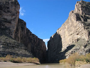
Photo courtesy of the National Park Service<
Mouth of
Elena Canyon
Big Bend is not
one of the easiest places to visit when arriving from a distance.
Whatever means of transportation you have to get into big, big
Texas, you will need a car to get into the Big Bend Area. The
nearest airport served by commercial airlines is more than 250 miles
away. Train service and bus lines can get you within 100 miles.
Rental cars are available at many locations. Being off-the-beaten-
track is one of the attractions of this area. Getting there might
not be half the fun, but all along the trip will be enjoyable.
Presidio on the Rio Grande just west of the Big Bend Ranch State Park is
a place to start your visit. The state park extends from just east of
Presidio to near Lajitas. Drive through the southern section of the park
along route 170—Camino Del Rio, or River Road—between the towns. Camino
Del Rio twists and turns, climbs mountains, crosses arroyos, and hugs
canyon walls. At the top of “the Big Hill” you can look deep into
Mexico, west into Colorado canyon and east 75 miles to the Chisos
Mountains. The drive can be a challenge. There are few shoulders. The
Big Hill is one of the steepest grades on a Texas highway. There is open
grazing so you might find cows, horses, burros, or mules on or right
next to the pavement. Take it slow to be safe and to enjoy the views.
At Presidio, you can cross the Rio Grande into Ojinaga, Mexico. Both
towns were originally one before the Rio Grande became a borderline
between two nations. In this town just south of the border you will find
shopping at bargain prices and fine eating establishments. The bakery—Panaderia
la Francesa—in downtown Ojinaga is well known for its bread and pastries
baked in adobe ovens. The people are friendly and welcome tourists.
Three miles east of Presidio on route 170 visit the Fort Leaton state
historical site. It is a massive adobe fortress built by Ben Leaton in
1848 immediately after the Mexican War. This frontiersman had a
profitable trade with native Apache and Comanche tribes, supplied U.S.
Army patrols, and was even accused of encouraging Indian raids on
settlements in Mexico. Twenty-four of the original 40 rooms have been
restored and work is progressing on the others. Entrance fee is $2 per
adult.
Twelve miles before reaching Lajitas stop at historic Terlingua,
referred to as the “Ghost Town.” From the turn of the last century until
after World War II, Terlingua was the home of Chisos Mine, which
extracted cinnabar, or mercury ore. Several structures in Terlingua have
been restored or stabilized. Shops and restaurants now occupy the main
building that once was the largest store between El Paso and Del Rio. A
new generation of inhabitants has restored some of the miners’ stone
cabins. Much of historic Terlingua is private property, but the helpful
people at the Terlingua Trading Company can quickly tell you what areas
are off limits. The music scene is lively for a community as remote as
Terlingua. It is a unique Big Bend-West Texas sound that the local dance
bands often take to other parts of the Lone Star State and frequently to
other parts of the world.
The state park is composed of almost 300,000 acres containing two
mountain ranges that include extinct volcanoes, waterfalls, and sheer
canyons. It was purchased from the private owners in 1988, and a small
herd of Texas longhorns is maintained as a reminder of the ranching
heritage. Just east of Lajitas is where you will enter the other park
area—Big Bend National Park.

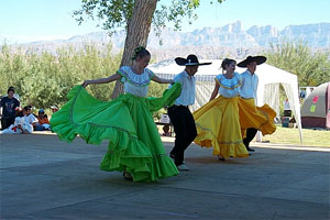
Photo courtesy of the National Park Service
entertainment in Big Bend National Park
While in the area
take a drive up highway 385 to the town of Marathon, considered the
northern entrance to the Big Bend Country. A sea captain suggested
the name because it reminded him of Marathon, Greece. Today, the
town is headquarters for vast ranching activities and its historic
past can be visited at the town museum and the old town jail. Five
miles south of town on the Post Road visit the remains of Fort Pena,
Colorado. The fort was constructed in 1879 to protect area residents
from Indian raids. The fort was abandoned in 1893, after the army
defeated the last of the wild Apaches, but some of the original
foundations can still be seen. Today the site is a public park.
Thousands of visitors come to the Big Bend Country every year so
there is a wide range of accommodations from different levels of
camping to resorts to pamper you. There are fees to enter the
National Park.
Details
How
To Get There
Midland/Odessa is the nearest place with scheduled airline
service. El Paso also has scheduled air service. Either is as
close as you can come by commercial air transportation. Each is
roughly 250 miles away from the Big Bend area. (With your own
plane—or if you charter a flight—land at the Alpine-Casparis
Municipal Airport at Alpine.) Rail and bus service take you to
Alpine, but not all trains stop at this town so check your
schedules or arrange your travel through a travel agent.
Where to Stay
What you intend to do on your visit dictates where to stay.
Accommodations range from the basic campsites through bed and
breakfasts and modest hotels to plush resorts. For campgrounds,
the entrance fee of $15 a week per vehicle covers use of a
campsite.
In
Marathon, the restored West Texas Hotel, built in the 1920s, has
ranch-style furnishings and a restaurant serving traditional
Texas fare. Rates vary greatly from $65 to $225. The Marathon
Motel has 10 rooms, an RV park and campsites. It is on 10 acres
with unobstructed views of mountain sunsets and starry skies. In
town is the Gage Hotel and a B&B adjoining.
In the
Big Bend National Park the Chisos Mountain Lodge has 72 rooms,
post office, and convenience store.
In
Lajitas on Highway 170, between the national and state parks,
the Lajitas Resort has 72 luxury hotel rooms, two restaurants,
bar, swimming pool, shops, and 18-hole golf course.
Terlingua Ranch and Cabins offer secluded accommodations with
pool, restaurant and quick access to many miles of back country.
WTA’s Travel Access Discount Program serves up deeper discounts on hotels, car rentals, flights, and activities all over the world. Most of our travel deals are not available to the public, which means rates are much lower than what the average consumer can find online. Click here to start accessing for free today.
Where
to Eat
A wide variety of eating establishments are in the area with
most having the Mexican or Tex-Mex flavor. There is a rich
variety of places, but not all of them serve three meals. Some
are open only for dinner. A few places you might want to try
are:
-
Cafe Cenizo and White Buffalo Bar. Near Gage, this place
serves creative regional cuisine with the Mexican and West
Texas flair. Breakfast and dinner daily, but lunch only on
Sundays.
-
Candelilla Cafe on Highway 179 near Lajitas. Open breakfast,
lunch and dinner for an extensive menu of regional
specialties. Glass on three sides gives excellent view of
amazing sunsets. Next door, drop in to the Thirsty Goat
Saloon, an upscale western bar often providing live music.
-
El Patio in Presidio features is considered that town’s
favorite eating establishment. Mexican food, beer, ice cream,
salad bar.
Notice: This
information is current as of October 2004. It is recommended that you
contact the numbers, and/or visit the websites above to determine any
changes to the information.
|